

HAILTRACKER®
UPDATES
HailTracker® Update - May 19, 2025
HailTracker Expands - Now with Rainfall, Flooding & GIS Layers
Weatherwatch is excited to announce new features in the latest HailTracker update, allowing users to more easily access weather data in one centralised platform.
Virtual Rain Gauge Network
All HailTracker users now have access to the Virtual Rain Gauge Network. By combining real-time rainfall measurements with radar data, the network displays live rainfall totals for up to the past 7 days.
Live & Historical Rainfall Gauges
View live rainfall data across Australia using information from the BoM’s extensive rain gauge network. Select timeframes from the past hour to the past 7 days, with archive data available from the start of the year (with more to come in future updates), giving users expanded access to historical weather data.
Live & Historical Flood Heights
Access flood height data across Australia, including interactive flood height graphs. Archive data is currently available from April 1, 2025, helping users track and visualise flood movement over time.
LGA, Suburb & River Basin Overlays
See exactly where hail, rain, and flooding is occurring with new visual boundary overlays for LGAs, suburbs, and river basins across Australia.


HailTracker® Update - April 10, 2025
HailTracker climatology database
Thanks to a revolutionary update in HailTracker's internal database, users can now generate custom hail climatology maps that update in real-time. This provides valuable insights into not only the risk of hail at any location, but the inter-seasonal risk of hail at these areas.
For more information, see our article on some of the insights.
Users can view hail frequency charts across Australia.

HailTracker® Update - February 16, 2025
HailTracker now includes the entire Australian radar database
HailTracker now contains up to 30 years data for select radars with the entire Australian radar database now processed. This provides the largest, readily accessible available hail mapping archive in Australia.
HailTracker® Update - January 3, 2025
Introducing Storm Intensity Maps for 2025!
Now available for selected Australian radars, Storm Intensity Maps estimate the severity of thunderstorm activity, helping you identify storms capable of producing strong or damaging wind gusts and hail.
These maps go beyond traditional hail detection, offering enhanced insights to better understand storm dynamics and potential risks out to 256km from the radar.
More radars will be added in the coming weeks and months—stay tuned for updates.

Want to see Storm Intensity Maps at work? Check out the Broken Hill supercell analysis.
HailTracker® Update - October 11, 2024
Simplify your weather insights with Forecast MetGraphs.
Powered by MetCentre, MetGraphs combine temperature and rainfall forecasts into one quick and powerful tool for any location in Australia. Easily spot outliers during extreme weather events by comparing data from multiple sources simultaneously.
MetGraphs make it easier than ever to gain clarity during significant temperature or rainfall events, empowering you to make informed decisions with confidence.
.
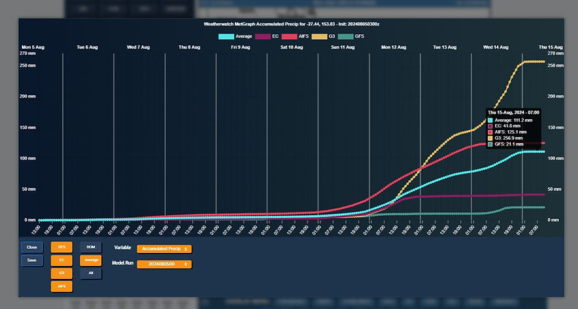
Ensure you have "MetGraphs" selected on the left hand function menu and then click anywhere on the map to obtain a MetGraph forecast.
HailTracker® Update - July 31, 2024
Forecast model data, now in one intuitive platform.
Responding to popular demand, we’re excited to introduce our first forecast weather data model, seamlessly integrated into the platform you know and trust.
This marks the beginning of many forecast updates to come. Over the coming months and beyond, expect
more forecast data enhancements to ensure all your essential weather insights remain accessible within our easy-to-use system.

