Disappearing Cold Fronts Drive Warm April & Divided Rainfall Patterns for Eastern Australia
- Weatherwatch
- May 1, 2025
- 3 min read
May 1, 2025
It’s been a remarkably warm April across eastern Australia, largely due to the absence of cold frontal activity. This pattern has allowed persistent easterly winds to dominate the region, leading to unseasonably warm nights and above average rainfall across much of Queensland and coastal NSW. Meanwhile areas of Victoria have experienced well above average temperatures including Melbourne.
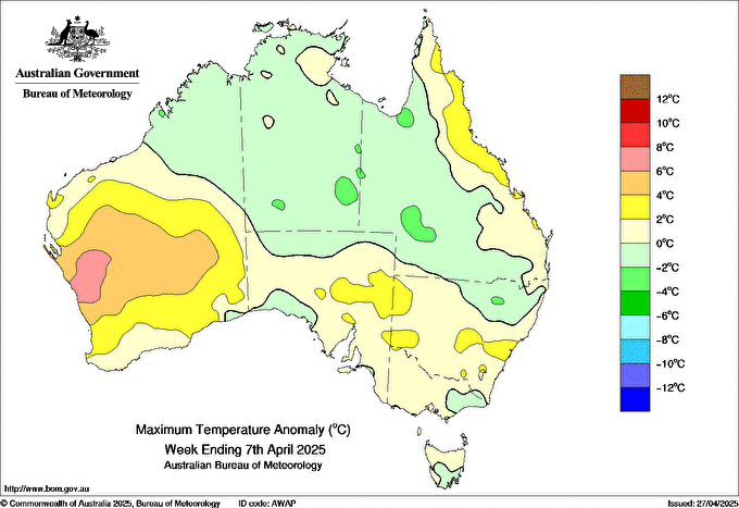
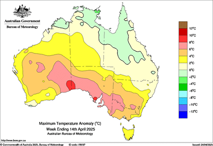
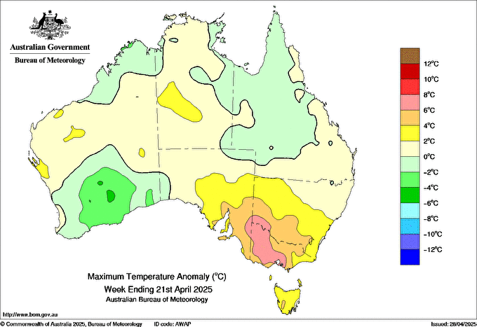
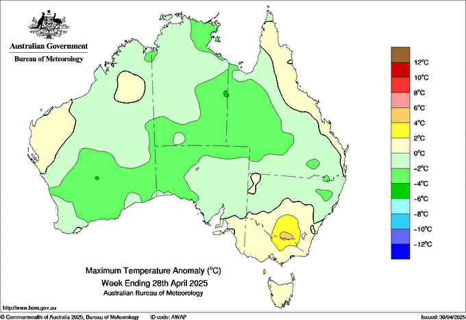
Weekly maximum temperature anomalies during April showing broadly above average temperatures, particularly across southeastern Australia. Source: Bureau of Meteorology.
Brisbane: Warm Nights, Average Days
Brisbane recorded an average minimum of 18.4°C, 1°C above the long-term average, making it the warmest April for overnight temperatures since 2016. Daytime temperatures were close to average, with a maximum of 27.4°C, just +0.2°C above the long-term norm.
Sydney: Warmest April Since 2018
Sydney also experienced elevated minimums, with an average of 16.4°C, sitting 1.6°C above average, and the warmest April minimums since 2018. Daytime temps were notably high too, averaging 25.4°C, nearly 3°C above normal, also the warmest since 2018.
Melbourne: A Standout April
Melbourne saw the most dramatic deviation, with an average April maximum of 23.4°C—a whopping 6°C above average, making it the warmest April for daytime temperatures in 20 years. Overnight lows were 13.7°C, nearly 4°C above average and the warmest April minimums since 2010.
Adelaide & Perth: Warmth Lingers into the West
Adelaide recorded an average maximum of 25.4°C, its warmest April since 2018. Perth didn’t see dramatic daytime warmth, but warm nights prevailed, averaging 14.8°C, the warmest April minimums since 2016.
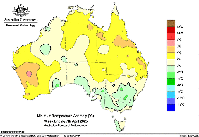
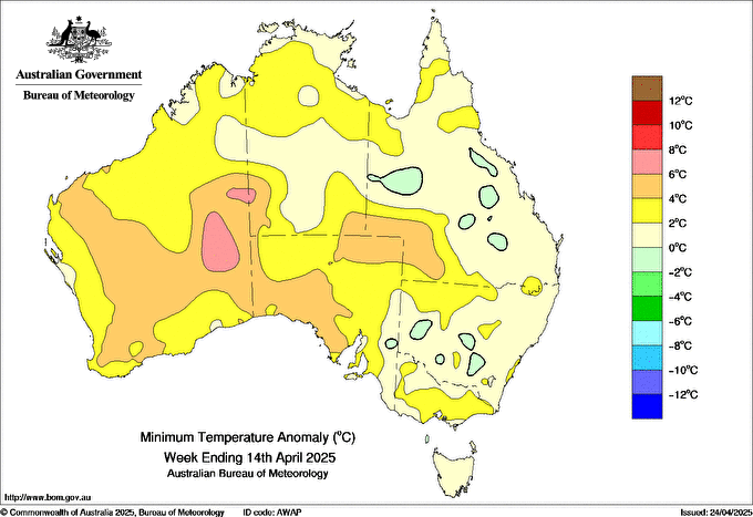
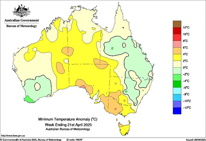
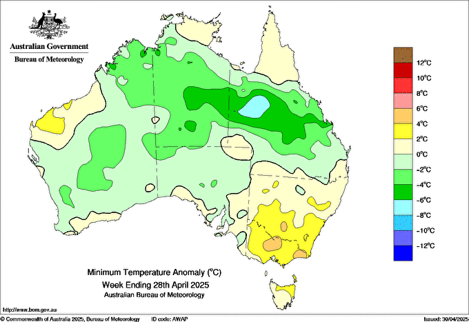
Weekly minimum temperature anomalies during April showing broadly above average temperatures though drier air in the last week of April pushed into central Australia and areas of Queensland, dropping minimums. Source: Bureau of Meteorology.
The Dry Reality for Southern Australia
While easterly winds brought rain to eastern Queensland and NSW, they had the opposite effect for inland NSW, Victoria, South Australia and Tasmania. April usually marks an uptick in cold frontal activity, bringing cooler temperatures and rain, but the absence of these systems has prolonged the dry spell for these regions.
Even Perth, which relies on cold fronts for autumn rainfall, continued its dry streak—though some relief is expected tomorrow and Saturday with a passing front.


It's not just April that's been dry across southeastern Australia - it's been dry since to the start of the year with rainfall mostly remaining in Queensland, eastern NSW and areas of Western Australia. Source: Bureau of Meteorology.
Blame the SAM: Southern Annular Mode to Thank
The culprit? A stubbornly positive Southern Annular Mode (SAM). A positive SAM causes the belt of strong westerly winds around Antarctica to contract southward, pushing cold fronts away from mainland Australia. The result? Dry weather for southern states and persistent easterlies for the east coast.

Extended 'Wet Season' for Eastern Queensland?
Conversely, the persistent easterly trade winds have prolonged the 'wet season' in eastern Queensland driving increased rainfall with this trend potentially likely to continue for the foreseeable future until the westerly influence that cold fronts tend to bring finally arrives.

Until the pattern switches, we can expect below average rainfall potential across southern areas of Australia while more persistent showers and a higher chance of rainfall may persist across the east coast.
Weatherwatch – your trusted partner in weather intelligence.