Ex-Tropical Cyclone Dianne to Help Fuel More Rain for Queensland – But Light at the End of the Tunnel
- Weatherwatch
- Mar 30, 2025
- 2 min read
March 30, 2025
A Wet Start to 2025
Areas of southern Queensland are finally catching a breather after a sodden start to the year. The deluge began with major flooding around Townsville and the northeastern coastline, continued with Tropical Cyclone Alfred in the southeast, and more recently shifted inland—where some regions have recorded their annual rainfall in just one week. Renewed flooding has also emerged across parts of southeastern Queensland due to fresh heavy falls.


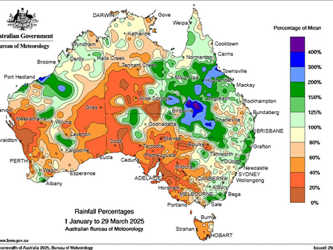
Rainfall since the start of 2025 has seen much of Queensland and northeastern NSW 'steal the show' with respect to rainfall. Southern Australia has remained much drier. Source: BoM
More Rain on the Way—But Lighter Totals
Unfortunately, more rain is expected this week. While that may be welcome news for those who missed out earlier, it's a concern for areas still recovering from flooding or where catchments remain saturated. The good news is that forecast totals are lighter than in previous events.
Even so, with wet catchments, it doesn't take much additional rain to cause renewed river rises or flooding.

Outback Queensland has turned into an inland sea. Source: Weatherwatch HailTracker
Ex-Tropical Cyclone Dianne to Fuel Rain
A recent East Coast Low brought a brief window of drier, more stable air into southern Queensland, pushing most shower and storm activity northward. But now, Ex-Tropical Cyclone Dianne is entering the picture.
Dianne crossed the Kimberley coast on Friday night as a category 1 system before weakening over inland Western Australia. The remnants of the system are now tracking southwards and are expected to collide with an approaching upper trough. This interaction will increase wind shear and help "pull apart" Dianne, sending a new surge of moisture east into Queensland.
Importantly - Ex-Tropical Cyclone Dianne itself will not move into the state, only the moisture will, so no strong winds or overly intense rainfall is expected.

EC precipitable water & 500mb wind barbs showing moisture from ex-TC Dianne being pushed into Queensland, helping to fuel more rainfall. Source: Weatherwatch MetCentre
Totals Still Manageable—But Caution Needed
Widespread 30–50mm falls are likely across the state, with isolated totals of 50–100mm. While these amounts are modest by Queensland standards, the saturated ground means even modest rainfall could cause renewed flooding in some locations. However, at this stage, the risk of significant new flooding or major escalation of current flood conditions appears lower.

EC forecast rainfall this week over Queensland. Source: Weatherwatch MetCentre
Climatic Patterns Suggest Drier Times On the Way for Queensland (For Now)
Looking further ahead, a drier and more stable airmass is expected to arrive later this week. This should finally bring a more decisive end to the persistent wet pattern.
The shift is also thanks to the Madden-Julian Oscillation (MJO) pulse moving away from Australia which will help decrease tropical activity and generally coincides with decreasing rainfall. A slow increase in cold frontal activity will also help to flush out the recycled moisture that’s been lingering across the state in recent weeks.

MJO is shifting away from Australia helping to reduce the amount of tropical activity. Source: BoM
Weatherwatch – your trusted partner in weather intelligence.