Grey Skies May Cloud Storm Potential but More on the Way for Queensland
- Weatherwatch
- Oct 27, 2024
- 2 min read
October 27, 2024
An upper trough is responsible for a band of rain, showers, and storms stretching from the Gulf Country to the NSW/QLD border. Today, this system produced an 83km/h gust in Charleville along with nearly 10mm of rainfall.

Satellite, radar and lightning imagery showing a broken band of showers and storms across inland Queensland. Source: MetCentre.
Tomorrow's Storm Development: Contingent on Cloud Cover
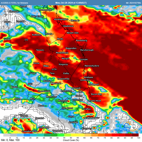
This system is expected to track eastwards tomorrow (Monday), bringing cold air into the upper atmosphere across SE QLD and NE NSW, which could increase instability. However, leftover showers and cloud from earlier activity in southern Queensland are introducing some uncertainty.
Cloud cover can inhibit storm development by blocking sunlight, reducing the heat that fuels thunderstorms. For areas like the Darling Downs, this cloud cover should clear, allowing more sunlight to reach the surface, helping to initiate showers and storms that may extend into northeastern NSW.
ACCESS LIs showing weak to moderate instability over parts of southern Queensland and NE NSW tomorrow. However, ACCESS cloud (and other models) hold cloud over the more populated Southeast Coast region for longer which may take the edge of storm potential. Source: MetCentre.
While conditions aren’t overly volatile, the upper trough will bring the potential for pockets of large hail and localised damaging wind gusts. Thankfully, most people will likely see non-severe storms, with stronger activity expected to remain more localised.
What to Expect on the Southeast Coast
For the populated Southeast Coast, cloud cover may linger, potentially reducing storm chances. However, if clouds clear earlier in the morning, storm chances will increase. Regardless, some afternoon storms could nudge into the western and southern parts of the district. For metropolitan areas, storms will depend largely on the extent of morning cloud, with occasional thunder or lightning possible.

ACCESS rainfall is more favoured away from the metrpolitan areas. Source: MetCentre.
Looking Ahead: Higher Storm Potential Later in the Week
Later in the week, another equally strong upper trough will push into SE QLD and NE NSW. Warmer temperatures combined with moisture could result in greater instability, increasing the risk for storms and severe storms. However there is still uncertainty as there is the potential for drier air to lie close to the coastline which would reduce storm potential. Our team will be watching this setup closely!
ACCESS LIs for Thursday showing stronger instability along the coastline. However, instability may exist along a narrow band thanks to moisture remaining coastal as drier WNW winds push in from the west. Source: MetCentre.
Weatherwatch – your trusted partner in weather intelligence.


