
Turbulent Spring Weather Ahead for Australia as Antarctic Polar Vortex Weakens
- Weatherwatch
- Sep 25, 2025
- 4 min read
The Antarctic polar vortex is weakening, setting up a potentially more turbulent spring for Australia. Some of the potential impacts include:
More cold fronts sweeping across southern states
Greater potential for damaging winds and heavy rain in the south
Elevated fire danger in northern Australia
Possible increased risk of storms along the east coast (decreased confidence)
What is the Polar Vortex?
High above Antarctica in the stratosphere, about 30 km above the surface, lies a powerful circulation of westerly winds called the polar vortex that determines where the belt of westerlies sits across the Southern Hemisphere.
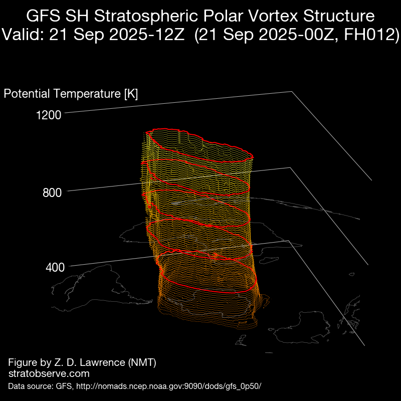
As spring sunshine returns, the vortex begins to weaken and temperatures in the stratosphere rise which can cause the winds to weaken. While this is normal - the rate this is weakening is faster than normal with a sudden increase in temperatures at the stratosphere level which is causing the vortex to become distorted.


Forecasts show the Polar Vortex should remain elongated and displaced over the coming weeks, shifting towards South America and South Africa.
Minor Sudden Stratospheric Warming (SSW) Event Underway
While not as dramatic as the 2019 SSW event (one of the most significant in recent decades) the event is still significant. Winds 30km above the surface have weakened markedly, with strong westerlies displaced toward South America and South Africa, and even easterlies appearing in the Australian sector of the stratosphere. This distortion indicates a stressed vortex and sets up a chain reaction that can extend downward into the troposphere (the layer of the atmosphere where the weather occurs) over the coming weeks.

What This Means For Australia
A weakening, distorted vortex tends to project downward as a negative SAM (Southern Annular Mode) pattern. In essence, it results in cold fronts shifting further north than normal which causes a variety of impacts. However this is likely to be quite different to the 2019 SSW event. Aside from being weaker, the 2019 SSW event coincided with a record positive IOD and weak El Nino. The increase in winds and absence of moisture from these events created the perfect storm for a horror season of bushfires.
This year the patterns are quite the opposite, there's a negative IOD (which often supports rainfall), and a weak La Nina in the Pacific Ocean (which helps bring additional coastal moisture).


BoM indicated a weak La Nina pattern (or cool neutral), while a strongly negative IOD is present. These can correlate with increased rainfall across central to eastern Australia during spring and sometimes parts of summer.
Bringing this altogether is challenging as we don't have any analogous years to compare against, but:
Southern Australia (SA, VIC, TAS, southern NSW): More frequent cold fronts, stronger westerly winds and more gales, and an increased risk of rainfall (particularly in Tasmania).

Eastern seaboard: Negative SAM phases correlate with an increase potential for hail and thunderstorms for Brisbane, but a decrease chance in Sydney. Conversely, La Nina patterns can increase the chance of hail in the early season (while providing a lower chance of hail overall). It's a tricky balance, as if the amplitude of the cold fronts doesn't extend far enough north, it could result in ridging across the central eastern seaboard which would detract from storm activity. Regardless, above average temperatures are a likely scenario, and should the fronts shift northwards, it could see a rapid increase in storm activity.

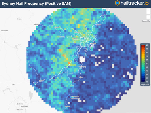


The frequency of hail can change during negative SAM phases according to hailtracker.io
Northern Australia: An increase in westerly winds across the south may cause high pressure systems to sit further north at times, resulting in a higher potential for bushfires.

Western Australia: Wetter conditions across the southwest, but potentially a little drier elsewhere.
The unknown here is how the increase in cold fronts may interact with the negative IOD. That's because the vortex is displaced at an angle towards South America and South Africa as opposed to Australia. This could actually result in more frequent but low-amplitude cold fronts (as opposed to high-amplitude cold fronts that could extend further north to tap into the moisture from the Indian Ocean and drag it cross).

Higher Risk Weather Season
As we enter the official Higher Risk Weather Season, the combination of a weakening polar vortex, increased cold fronts, and uncertain climate drivers means the weeks ahead could bring a range of disruptive weather. From damaging winds and heavy rainfall to hail and thunderstorms.
That's why staying informed matters. At Weatherwatch, our team of meteorologists are closely tracking these patterns and providing timely updates to our stakeholders. Tools like HailTracker.io and our broader suite of weather intelligence services give businesses the clarity they need to prepare and respond confidently.
Weatherwatch – your trusted partner in weather intelligence


