Heaviest Snow in At Least 41 Years for Northern NSW
- Weatherwatch
- Aug 3, 2025
- 3 min read
Updated: Aug 3, 2025
August 3, 2025
A low off the NSW coastline produced heavy falls across the central third of the coast, with widespread totals of 75-125mm recorded, and some local falls exceeding 175mm over a three-day period. Damaging winds over 100km/h were also observed, particularly along the Hunter Coast.

Max 24 hour wind gust recorded: A low off the NSW coastline produced damaging wind gusts exceeding 90-100km/h in coastal areas. Source: HailTracker.io
Near Half-Metre Snowfall Transforms the NSW Northern Tablelands
However, the most remarkable impacts came from the snow - in a region where snowfall is usually measured in centimetres, not feet. More than a foot of snow fell across parts of the Northern Tablelands, with some of the heaviest accumulations actually occurring at lower elevations than normal.
Armidale, Uralla, and Guyra were transformed into winter wonderlands, with road closures across the region. Current indications suggest this is the heaviest snow in the region since at least 1984, though some areas may have recorded even higher totals this time. The 1984 event was more widespread, including substantial snow across parts of southeast Queensland.


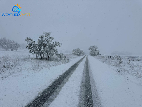
Weatherwatch meteorologist Nick Thompson captured the heavy snowfalls around Guyra.
Light Snow and Small Hail for QLD
Further north, light snow was reported around Stanthorpe, while hailstorms brought small hail to Toowoomba, Warwick, and parts of southeast Queensland. Thankfully, this hail was small and soft enough not to cause damage (which is typical of hail in these types of setups).

Small hail occurred near the town of Grandchester - one of many locations that recorded small hail.
Very Strong Upper Low Caused Snow
The culprit was a powerful upper-level low, bringing temperatures around 14°C below average in the upper atmosphere for this time of year. The airmass was exceptionally cold -even by Victorian standards with 500mb (5.5km height) temperatures falling below –28°C.

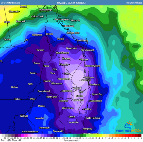


GFS 500mb temperature and 500mb temperature anomaly showing the magnitiude and intensity of the cold air in the upper atmosphere. Source: MetCentre.io
The air was so cold that in combination with the warmer ocean temperatures, it induced a low off the coastline, feeding in humid, easterly winds into the system. That mix of cold air and abundant moisture led to heavy rain at lower elevations, and very heavy snowfalls at higher ones.

72-hour accumulated recorded rainfall totals across the Hunter and surrounds. Source: HailTracker.io
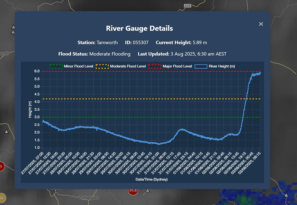
Rivers rose rapidly due to the saturated catchments across the region. Source: HailTracker.io
Snow From the East & Northeast - A Rare Direction
Snow across the northern NSW ranges typically comes from westerly winds - but this time, it drifted in from the east and northeast, an extremely unusual setup. But that didn't stop a very cold day from occurring due to the very cold air in the upper atmosphere mixing down to the surface. Armidale's maximum temperature for the day was 1.3C at 9am - after that the temperature dropped and hovered around 0C for much of the day.
Improving Conditions Ahead
Today, a secondary low will intensify further offshore, shifting the focus of rain away from the coast. That’s good news for catchments and rivers, which have responded quickly this year due to already wet conditions. However, gale-force and localised damaging wind gusts remain possible across northeastern NSW today.


EC wind gusts for Saturday afternoon (yesterday) vs this afternoon (today) showing that the impacts of the low will contract offshore today and gradually ease. Source: MetCentre.io
Conditions are expected to improve further into tomorrow.
Weatherwatch – your trusted partner in weather intelligence