Low to Lash East Coast with Gales, Rain & Cold Conditions
- Weatherwatch
- Sep 25, 2024
- 2 min read
September 21, 2024
A Cold, Wet, and Windy End to the Week
It's set to be a cold, wet, and windy end to the week, thanks to a developing low off the NSW coastline that's expected to track northwards, reaching off the southern Queensland coastline by the weekend.
Upper Trough to Induce a Low off the NSW / QLD Coastline
A large, slow-moving upper trough, which has already produced extensive unseasonal rain and storms across central Australia, will move into NSW tomorrow and Friday. It's expected to interact with the unusually warm ocean temperatures off the NSW coast for this time of year and develop into a low-pressure system. As the upper trough approaches, it will cause air to rise quickly, leading to the formation of the low-pressure system.

G3 500mb temperatures for Friday showing a sharp upper trough across NSW. Source: Weatherwatch MetCentre
Gale-Force Gusts Expected
This will result in strong and gusty S/SE winds developing along the central NSW coastline tomorrow, extending into northeastern NSW and southeastern Queensland by Friday and Saturday. Gale-force wind gusts are likely, especially along the NSW north coast.
EC 850mb Winds for Friday and Saturday over NE NSW & SE QLD. Source: Weatherwatch MetCentre
Heavy Rainfall and Showers for Parts of NE NSW
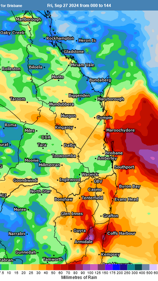
The presence of these strong winds pushing humid Tasman Sea air onto the coastline under a cold pool of air in the upper atmosphere will generate frequent showers and rain, particularly around the Mid North Coast and Northern Rivers of NSW, where falls may exceed 100mm or more.
Accumulated forecast rainfall for GFS, EC and G3 for the next 6 days. Source: Weatherwatch MetCentre
Southeast Queensland: Windy & Showery with Chilly Temperatures
For Southeast Queensland, rainfall may be lighter, but it’s unlikely to be a great final weekend for the school holidays. Strong and gusty southerly winds will whip up larger waves and swells, making temperatures and conditions along the beach feel quite miserable. On Saturday afternoon, apparent temperatures are likely to hover around the mid-teens on the Gold Coast, while on the NSW North Coast, they may struggle to reach double digits due to wind chill from the strong southerly winds.

GFS apparent temperatures on Saturday afternoon showing significant wind chills expected. Source: Weatherwatch MetCentre
Key Concerns: Winds and Swells, Local Heavy Falls Possible (NE NSW)
Fortunately, some of the heavier rainfall forecasts have decreased in intensity, although isolated heavy falls can't be ruled out. Winds, large waves, and swells are likely to be the main concerns. However, this will ultimately depend on the low's movement, which forecast models are still fluctuating on in terms of timing and positioning.

Weatherwatch MetGraph for Ballina showing some models supporting heavy rainfall along parts of the NE NSW coastline. Source: Weatherwatch MetCentre
Water Activities Not Advised
Those considering coastal water activities over the coming days should reconsider, while residents and businesses are advised to monitor weather conditions in case the situation changes.
Weatherwatch – your trusted partner in weather intelligence.


