North Queensland Deluge Continues – Flood Risk Spreading Inland
- Weatherwatch
- Feb 2, 2025
- 3 min read
February 2, 2025

24 hour rainfall totals overlaid on the Townsville radar showing more than 700mm to the north of Townsville. Source: MetCentre
The past 24 hours have seen staggering rainfall totals, with more than 700mm recorded at Paluma and Rollingstone. This has resulted in major flooding, with Ingham likely to reach its record flood height of 15.2m, last seen in 1967.
Unfortunately, more heavy rain is on the way, even as the main tropical low moves further inland. That’s because the primary driver of the rainfall is actually a trough extending east from the low, which is expected to remain nearly stationary across northeastern Queensland for another 36 to 48 hours.

Why Is Rainfall Continuing?
This trough is acting as a collision zone between:
Humid southeasterly winds from the Coral Sea
Moist northerly winds wrapping around the low from the monsoon trough
Both air masses are extremely moisture-laden, fueling continued torrential rainfall over already saturated ground. Over the next 24 hours, rainfall totals could match or even exceed what has already fallen, meaning another 250-500mm (and locally higher totals) are possible in areas already experiencing major flooding.

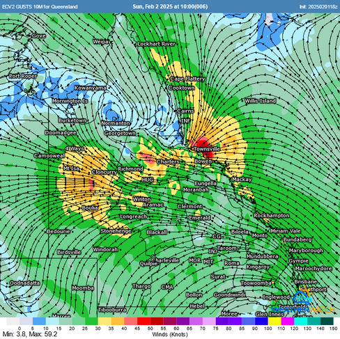

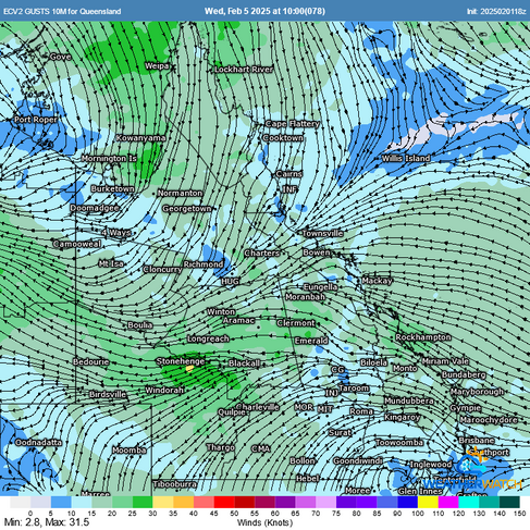
EC winds today vs Wednesday. Note that the position of the convergence zone and trough is still virtually in the same location, however the winds are weaker by Wednesday. Source: MetCentre
When Will This Event Ease?
The trough itself is expected to persist for much of the week, but the worst of the rainfall should gradually weaken over the coming days. However, Townsville and surrounding areas remain under heightened flood risk until midweek.
Unfortunately, the inland flood risk is now increasing as moisture is drawn further west along a trough system. While inland rainfall will not be as extreme as coastal areas, catchments in northern Queensland are large and highly responsive. Falls of 150-250mm could still contribute to significant riverine flooding by mid to late this week.

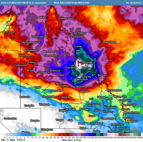


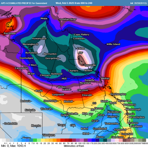
Forecast rainfall for the next 10 days across Queensland shows that heavy rainfall is likely to spread inland later this week potentially bringing new areas under a flood threat. Source: MetCentre
Tropical Cyclone Activity - No Australian Mainland Threat
A tropical cyclone risk remains in the Indian Ocean, but these systems are expected to move away from Australia. This is due to a mid-level ridge over WA, which is steering potential cyclones westward.
Similarly, two additional low-pressure systems near the Pacific Islands have lower confidence of developing into tropical cyclones. Even if they do, an upper trough is expected to guide them southeast, away from Australia. Ironically, this same upper trough has been responsible for stalling the system over northern Queensland, prolonging the heavy rain.

What You Need to Do
With further significant rainfall and flooding expected, residents and businesses must remain vigilant:
Monitor warnings and updates from official sources
Stay in contact with friends and relatives, particularly those in high-risk areas
Evacuate immediately if directed by authorities
Avoid unnecessary travel – roads that were passable earlier may become impassable later
Never drive, walk, or swim through floodwaters – it’s not worth the risk
This is a serious and ongoing flood event that will continue for some time yet. Do not treat this like a normal event - some events are more extreme and this is definitely one of those extreme events. Stay informed, stay safe, and take action when needed.
Weatherwatch – your trusted partner in weather intelligence