NSW Braces for Rain, Snow & Gales as Another East Coast Low Looms - Strong Winds & Risk of Snow in Southern QLD
- Weatherwatch
- Jul 30, 2025
- 3 min read
July 30, 2025
August - Normally Dry, But Not This Time
Historically, August is one of the driest months of the year for the NSW coastline. But this year, it's shaping up to be quite wet thanks to the development of another East Coast Low. This system is expected to bring heavy rain, gale-force winds, and even the potential for heavier-than-usual snow along the northern NSW ranges. Some of that snow may even creep into the southern Queensland border - though this particular snow event is likely to be an "all or nothing" type.
Very Cold Air in the Upper Atmosphere to Drive Low
A broad region of very cold air already exists across the southeastern quarter of the country. An even colder upper-level pool is forecast to move northwest into South Australia later today, then track east/northeast towards the NSW/QLD border by Friday and Saturday.
As that happens, the combination of this cold upper air and relatively warm ocean temperatures offshore will help spin up a low-pressure system off the southern Queensland coastline on Friday. This low is expected to drift south and intensify late Friday into Saturday, pushing strong E/SE winds onto the central NSW coast.

ACCESS 500mb temperatures & low level winds for the coming days showing the upper cold pool inducing a low off the east coast. Source: MetCentre.io
Heavy Rain, Flood Risk & Coastal Gales
Those onshore winds could deliver moderate to heavy rainfall, potentially triggering flooding in parts of the region. Unlike July's earlier East Coast Low that resulted in very southerly winds, this system’s moisture may push further inland due to the more easterly component resulting a higher potential for rainfall. Gale-force wind gusts are also likely to occur across central eastern NSW, while damaging wind gusts may occur close to the coastline.

EC wind gusts for the weekend show gale force SE winds pushing moisture inland with the risk of damaging winds along the coastline. Source: MetCentre.io
The good news? Rainfall should ease quickly on Sunday as another low develops further offshore and the main energy shifts away. Still, expect a windy Sunday from Sydney to Brisbane with widespread gale-force gusts along the NSW northern coastline.


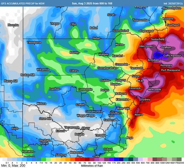
ACCESS, EC and GFS next 7 day rainfall. Source: MetCentre.io
Will It Snow? It Depends…
There’s been a lot of excitement about potential snow, with early model runs showing up to 14cm across the Granite Belt in QLD. That’s now eased to 1–2cm in more recent guidance, but some models still suggest up to 15cm could fall in the NSW Northern Tablelands.
The challenge with snow in these regions is that it’s very fickle. Sometimes it’s cold enough but too dry, or there’s moisture but it’s just a bit too warm. This time, moisture shouldn’t be the issue - but temperatures will be crucial.

Soundings like these are rare outside of alpine areas, where there is saturated atmosphere and sub-zero temperatures throughout the profile to the surface and can bring higher amounts of snow providing the lower atmosphere does not warm Source: MetCentre.io
Even a 1°C rise could turn heavy snow into sleet or rain. Still, if temps hold steady, there's a real chance of decent snow across the higher elevations of northeastern NSW.
A Spectacle or a Soggy Letdown?
If you’re thinking of chasing snow, keep expectations in check! A promising forecast doesn’t always translate to a snow-covered wonderland. Due to the high levels of moisture, the snow could potentially fall in a mixture of rain. That said, the ingredients are certainly there - and if temperatures can hover around 0C at the higher elevations there is the potential for some of the heaviest snow in recent years over the region. This will be the case even more so for the Granite Belt of Queensland where there will similarly be ample moisture - but it will be a battle of temperatures as to whether they can be hold enough to sustain snowfall to ground level.


GFS snow depth on Saturday afternoon and Sunday morning showing snow across the northern NSW Tablelands, possibly nudging into the QLD Granite Belt. Source: MetCentre.io
Wind & Waves Pose Bigger Risks
While the snow is grabbing attention, it's worth remembering this is part of a severe weather system. Windy conditions will dominate much of eastern NSW and southern QLD so avoid parking under trees and secure loose items. If you are travelling for the snow - remember that the roads may be wet, icy and slippery - and strong winds can cause large branches and trees to come down. Avoid parking under trees, secure loose items and be patient on the roads.
Those along the NSW central coast (particularly Illawarra, Sydney, Hunter and southern Mid North Coast) should also keep an eye on potential flood watches or warnings, and avoid the beaches over the weekend due to dangerous surf conditions.
Weatherwatch – your trusted partner in weather intelligence