SE QLD Rain Train Pushes Bremer & Logan Rivers to Major Flooding
- Weatherwatch
- Dec 1, 2024
- 2 min read
December 1, 2024

7-Mile Bridge (Ipswich-Rosewood Road). Source: Ipswich City Council Disaster Dashboard
As forecast yesterday, a slow-moving convergence line swept across Southeast Queensland, delivering 100–200mm of rain to already saturated catchments. After a wet and stormy November, the rainfall triggered rapid responses in local rivers. This morning, Boonah and Beaudesert are experiencing major flooding along Teviot Brook and the Logan River, while the Bremer River near Rosewood has also reached the major flood level (moderate flooding in town).
Major flooding is occurring along parts of the Logan and Bremer River Systems. Source: BoM
Monitoring Rainfall with the Virtual Rain Gauge Network
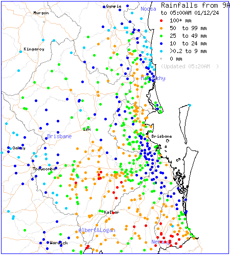
The rainfall was well captured by the Weatherwatch Virtual Rain Gauge Network, which combines real-time rainfall observations with radar data to provide a more comprehensive picture of rainfall on the ground. The network highlighted the heavy rainfall concentrated in the Bremer and Logan catchments.
Comparison between BoM rainfall gauges (left) and rainfall mapping via the Weatherwatch Virtual Rain Gauge Network (right).
Why Convergence Lines Matter
In recent years, convergence lines have been responsible for many significant floods across Southeast Queensland and eastern Australia. These lines form when two airmasses collide and push air upwards, creating showers and storms along a focused area.
Typically, upper-level winds move rainfall away from convergence lines, spreading it across a broader region and reducing prolonged impacts. However, when upper winds align with the convergence line, showers and storms repeatedly track over the same area, leading to concentrated heavy rainfall—exactly what happened yesterday.

Radar loop of rainfall on November 30, 2024. Source: MetCentre.
Thankfully, this convergence line only lingered over the region for a single day, unlike the multi-day events of 2022 and 2011.
Today’s Forecast: More Local Moderate Falls But Less Widespread
Unfortunately, more showers and storms are forecast for Southeast Queensland today. While upper-level winds are no longer aligned with the surface trough and convergence line, the winds remain weak, meaning showers and storms will be slow-moving.
In the current humid and unstable environment, some local moderate to heavy falls of 50–100mm are possible in some areas. While these totals are not extreme for Southeast Queensland, they could still cause renewed rises in already flooded catchments, particularly in upper river regions. However, today’s rainfall is unlikely to be as widespread as yesterday’s.
Forecast rainfall from GFS, ACCESS and EC for today. Source: MetCentre.
A Welcome Break on the Horizon
The good news is that more settled conditions are expected from tomorrow onward. Fine, very warm, and humid weather will dominate, giving affected areas much-needed time to dry out - this is important as it's never good to start the peak of the wet season with wet or flooded catchments.
Weatherwatch – your trusted partner in weather intelligence.


