Unseasonal Rain Event Looms for SE QLD & NE NSW
- Weatherwatch
- Aug 8, 2024
- 4 min read
August is historically one of the driest months of the year for Southeast Queensland and Northeast NSW – though it seems someone may have forgotten to tell Mother Nature that, with the potential for some moderate to locally heavy falls early next week.
Rainfall Driven by a Strong Upper Trough and Unusual Easterly Winds
The rainfall is due to a strong upper trough that will amplify into eastern Australia during Sunday and Monday. As it tracks eastwards, it will interact with warm and above-average ocean temperatures to develop a surface trough off the southern Queensland coastline. This will increase the onshore, easterly flow, pushing elevated levels of moisture into the upper trough, which will combine and condense into rain and showers.
To complicate things further, a small low may develop and become embedded in the trough. When this occurs, it can sometimes cause rainfall to contract southwards. Lows off the east coast tend to result in rainfall favoring the southern side – that’s because air rotates clockwise around low-pressure systems in the Southern Hemisphere, so if you’re on the northern side of the low, you’ll experience winds coming from the land, which tend to be a little drier.

GFS 500mb temperatures and low level wind barbs. Note the cold air in the upper atmosphere over NSW and southern Queensland and the long, easterly fetch of winds over the southern Coral Sea. These will combine to produce the forecast rainfall. Source: Weatherwatch MetCentre
Falls of 50-100mm Possible, Locally 100-200mm
While there’s the potential for some moderate to locally heavy falls, the forecast rainfall amounts remain variable and continue to fluctuate. The general trend so far has been a southward shift in the forecast rainfall – this means currently, northeastern NSW is more likely to experience heavier falls than southeastern Queensland, but we’ll continue to monitor this for any changes as there's a lot of variability. This is a common forecast variation – models often overestimate the northward extent of large upper troughs in long-range outlooks and then adjust closer to the event.
Given the nature of the event (offshore low and trough), rainfall will be quite coastal – with falls of 50-100mm possible over parts of Southeast Queensland, but this could reach 100-200mm along coastal areas of northeastern NSW and possibly around the Gold Coast and adjacent hinterland areas. Given it’s been quite dry lately, this will reduce the potential for flooding. However, if a convergence line develops, this could bring a higher chance of flash flooding. Unfortunately, convergence zones are often quite localized phenomena and are not well picked up by weather models until 1-2 days in advance but with any upper low and surface low combination there is always the risk of this occurring, particularly when the upper low is located to the north or northwest of the surface trough.


GFS, ACCESS-G, ECMWF & AIFS accumulated rainfall from Sunday - Wednesday. Source: Weatherwatch MetCentre
Sunday Night - Wednesday Morning Likely to be The Main Period of Rainfall
The main period of rainfall will commence later on Sunday as the trough takes shape off the southern Queensland and northern NSW coastline. Expect rain to continue across Southeast Queensland on Monday, possibly contracting more into NE NSW by Tuesday and then shifting away on Wednesday as the upper system drifts away. However there remains a lot of variability - not just between the models, but between the individual model runs themselves and we're seeing a lot of see-sawing in the outlooks. In the latest runs, EC/AIFS have held the rain back a little longer in SE QLD (while previous runs have pushed it into NE NSW more quickly). Conversely, the latest ACCESS and GFS runs are pushing it more quickly into NE NSW (while previous runs held it in SE QLD).
Negative Southern Annular Mode Fails to Deliver Westerly Winds
The rainfall may come as a surprise given the current climatic indicators. Sudden Stratospheric Warming (SSW) events tend to produce a negative Southern Annular Mode (SAM) phase. This has indeed happened, with a very negative SAM phase currently occurring.

SAM Forecast - shows a strongly negative phase that's shifting towards a neutral scenario over the coming weeks and weakening negative mode. Source: BoM
SAM phases traditionally result in westerly winds extending further northwards from the Southern Ocean. This has happened, but not in Australia. The likely reasoning behind this is two-fold:
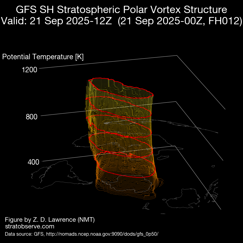
1. Polar Vortex Distortion: During SSW events, the polar vortex becomes distorted. In late July (when there were several strong cold fronts pushing through the country), the polar vortex was elongated so that it protruded towards Australia. Currently, the polar vortex is elongated so that it protrudes elsewhere in the Southern Hemisphere other than Australia (resulting in fewer westerly winds here, and westerly winds occurring elsewhere).


Comparison in the Polar Vortex between late July and early to mid August. Note in late July, the polar vortex was elongated towards Australia, this is no longer the case. Source: ECMWF
2. SSW Event Peaking: The current SSW event appears to have peaked, and forecasts suggest this may trend closer to normal now, with a return to a more neutral SAM phase.

GFS temperatures over Antarctica have cooled a little and are trending closer to the mean (red line). The green line indicates forecasts which suggests a push towards more average temperatures in the stratosphere. Source: NOAA
In the absence of the strong westerly wind belt, easterly winds have built and maintained across the Coral Sea. This has led to unseasonally high levels of moisture, providing fuel for rain and showers as the upper trough approaches.
We’ll be busy helping our customers during this time and keeping them updated. If we can help you out, please don’t hesitate to contact our amazing team of meteorologists!


