Brisbane's Wet and 'Haily' July as Second Winter Hailstorm Occurs Within a Week
- Weatherwatch
- Jul 24, 2025
- 3 min read
July 24, 2025
Prior to 2025, Brisbane has only recorded 2 hailstorms in July within 40km of the CBD since 1997 (2014 and 2003).
Hail drifts piled up against homes on July 18, 2025 as hailstorms tracked through western Brisbane. Then on the 23rd of July, small hail occurred across the northern suburbs of Brisbane though was generally not significant enough to produce damage.
Brisbane is no stranger to hailstorms being one of the most hail-prone cities in Australia. But while hail more commonly strikes between October and January, it’s rare during winter. Yet Brisbane has just been hit by its second July-winter hailstorm in less than a week, as unseasonal shower and storm activity continues across the region.


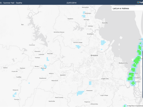


Using the historical hailfinder from from HailTracker.io - there's been 4 events in history within 40km of the Brisbane CBD since 1997 when hail has occurred during July. Two of them have occurred within the last week.
July's Average Rainfall in an Hour
Brisbane Airport recorded 30.2mm of rain. This is hardly news during the wet season, but in July, that’s nearly the entire monthly average delivered in under an hour.

It wasn't just hail - many places across Brisbane and Southeast Queensland recorded their average July rainfall in just an hour or two. Source: HailTracker.io
Winter Storms in Brisbane Are Unusual as it's the Dry Season
Winter storms in Brisbane and southeast Queensland are rare because the atmosphere is usually too dry. Typically, high pressure systems track over central Australia in winter, pushing dry, westerly winds across Queensland and northern NSW. This setup limits moisture, meaning even when troughs pass through, there’s not enough fuel for storm development.
This year is different. High pressure systems have been sitting further south than usual, allowing moist easterly winds to flow into the region. The result? Higher humidity and available moisture - an essential ingredient for thunderstorm activity.
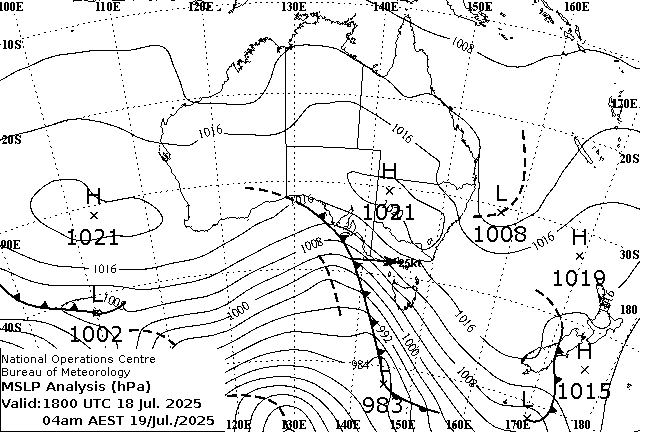
Comparison of weather charts. Typically high pressure systems are centred across central Australia and not the southern half of the country. This normally brings westerly winds across the SE QLD and NE NSW region (or the 'hail capital of Australia'). Source: BoM
Cold Air in the Upper Atmosphere Helps Storms Develop - Even When it's a Cool Day
Despite the increase in storm activity, daytime temperatures have remained mild. This is quite the contrast to the classic summer storm days, known for their oppressive heat and humidity. Thunderstorms develop when warm air rises - this means when the upper atmosphere is cool, the surface temperatures don't need to be as warm to generate storms.
Hail is Common in Winter (across the Southern States), but it's Normally Small
That same cold upper air also boosts the chances of hail. Almost all thunderstorms contain hail, but in summer, most of it melts before reaching the ground. In winter, the freezing level is closer to the surface, giving hailstones less time to melt allowing for more of them make it to ground level.
Winter hailstones also tend to be smaller. That’s because winter storms generally operate in environments of weaker instability. CAPE (Convective Available Potential Energy) a key measure of instability, is commonly less than 500j/kg in winter, but may be more than 2000-4000j/kg in summer. With less upward force to hold them aloft, hailstones will often fall to the ground before getting overly large.


Winter storms often occur with weak instability and low CAPE values. Summer storms are more likely to occur in strong instability and high CAPE values. Source: MetCentre.io
More Rain and Thundery Activity On the Way
Another trough system is forecast to move through on Saturday, bringing the chance of more showers, rainfall and possibly some thunder (though storm activity is more favoured for inland Queensland) which is continuing the very un-winterlike conditions for Brisbane.

Forecast rainfall during the next few days as another front approaches and combines with higher levels of moisture. Source: MetCentre.io
Weatherwatch – your trusted partner in weather intelligence.